

Dawn sky from Buck Hill this morning, March 10th. A huge bank of clouds on the eastern horizon, in an otherwise clear sky, prevented us from catching the sunrise. Still a nice crisp Monday morning pre-work hike.


Dawn sky from Buck Hill this morning, March 10th. A huge bank of clouds on the eastern horizon, in an otherwise clear sky, prevented us from catching the sunrise. Still a nice crisp Monday morning pre-work hike.
Dawn and sunrise this morning, February 22nd, from Buck Hill!


The Fore River Bridge, a vertical lift bridge, in the raised position, photographed from Buck Hill.
I have been up on Buck Hill a lot during the past two years, and yet yesterday was the first time that I have seen the Fore River Bridge in the raised position. I am sure those stuck in traffic did not enjoy this, but for me it was a rare treat.
The trail up was frozen over hard, very uneven terrain from the previous footsteps through the snow. It wasn't too cold, but wind gusts of 40mph and very turbulent air made for poor photography conditions. After photographing a couple of targets, I decided to pack things up. I brought along my camcorder to get some shots for a short film I am working on. That's when I noticed the bridge. I quickly ran back to get all the gear, setup as quick as I could, without extending the tripod, and got down on my knees in the ice and snow and managed to capture some images. Shortly after I started shooting, the bridge began to be lowered, so I just made it! The air turbulence is quite noticeable, but at least I got the shot!

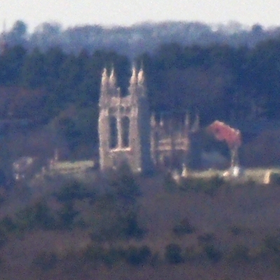
First Parish Unitarian Church (4 miles), 1508 Washington St, Canton MA and the Moose Hill Fire Tower (9.5 miles), Moose Hill Wildlife Sanctuary, 293 Moose Hill Parkway, Sharon MA photographed from Buck Hill.
, Sharon MA photographed from Buck Hill.")
The Jeremiah E Burke High School, 60 Washington St, Dorchester MA (6.37 miles) with five churches, photographed from Buck Hill. The high school building takes up almost the entire width of the image along the botton of the frame. The flag pole sits directly in front of the main enterance to the school on Washington St. The back entrance to the school is on Geneva Ave on the right side.
The five churches from left to right:
Twelfth Baptist Church, 160 Warren St, Roxbury MA (7.64 miles)
Resurrection Lutheran Church, 94 Warren St, Roxbury MA (7.77 miles)
Holy Tabernacle Church, 70 Washington St, Dorchester MA (6.33 miles)
St John Missionary Baptist Church, 230 Warren St, Roxbury MA (7.47 miles)
Roxbury Presbyterian Church, 328 Warren St, Roxbury MA (7.24 miles)
Roxbury Presbyterian has a the main steeple and then a smaller steeple which can just been seen to the right side of the high school. Holy Tabernacle is the only one of the five that is in front of the high school. Three of the churches are on the same street, Warren St in Roxbury.
In the background is One Dalton, the Sheraton Boston Hotel, and 177 Huntington (Christian Science Plaza) all in Boston MA. I have covered these buildings in earlier posts.
 with five churches, photographed from Buck Hill.")
New England Baptist Hospital, Parker Hill Avenue, Boston MA photographed from Buck Hill. This hospital consists of a campus of several older brick buildings. The flagpole is on the hospital campus. The hospital sits right at the edge of Mission Hill, which is why it can be seen so well, while many much taller buildings behind it are barely or not visible.
Behind and to the left is Mission Park apartment building, 835 Huntington Ave, Boston MA. To the right of that can be seen several rooftop exhaust pipes which are the very tops of two building in the Brigham and Women's Hospital complex on Francis St, Boston MA. A very large smokestack can be seen to the right. The sits right next to the Brigham complex and is Advanced Energy Systems Inc, 474 Brookline Ave, Boston MA.
There are two cell towers in the distance that can be made out. Much to my surprise, these are on Warner Hill in Derry NH and are over 47 miles away from Buck Hill. There is also a fire tower on Warner Hill, but it is either too short to be seen or is blending in with one of the cell towers.

Evans Biomedical Research Building, Boston University Medical Center, 650 Albany St, Boston MA photographed from Buck Hill.
I love when the air is still enough that the letters on the building can read!

Sunrise this morning, January 25th, from Buck Hill! Temperature was 10°F when we parked at the trailhead for the hike up.

Four television transmitter towers in Rehobeth MA photographed from Buck Hill. This cluster of towers serves the greater Providence RI viewing area. The towers are about 26 miles from Buck Hill.
From left to right they are:
WJAR (NBC ch 10), 95 Pine St, Rehobeth MA
WJAR backup tower, 95 Pine St, Rehobeth MA
WPRI (CBS ch 12), 195 Homestead Avenue, Rehobeth MA
WNAC (FOX ch 64), 34 Pine St, Rehobeth MA
A bit of a boring photograph, but interesting landmarks nonetheless. At my home in the suburbs south of Boston, my digital antenna can receive WJAR and WPRI quite clearly but does not detect WNAC.

Smokestack, SEMASS recovery facility, 141 Cranberry Highway, Rochester MA (though listed as West Wareham MA) photographed from Buck Hill. This smokestack is 32 miles from Buck Hill. To the right is a water tower, 319 Highland St, East Bridgewater MA at 12.7 miles.
To the left are three towers. From left to right these are:
Comcast tower, 815 Centre St, Brockton MA (10 miles)
cell tower, 223 Highland Ave, East Bridgewater MA (12.67 miles)
cell tower, 2 Bedford St, Brockton MA (8.19 miles)

Dawn and sunrise this morning, January 18th, from Buck Hill!


Sunny Side Cafe, 866 N Main St and West Corner Farm, 840 N Main St along with a stretch of MA-28 in Randolph MA photographed from Buck Hill.

First Parish Church of Dorchester, 10 Parish St, Dorchester MA photogrpahed from Buck Hill.

A snowy, early morning hike this morning, January 11th, including a traverse across the top of Buck Hill!


Dawn and sunrise this morning, January 4th, from Buck Hill!


Dawn and sunrise this morning, December 31th, from Buck Hill! Last sunrise of the year!
Happy New Year! Wishing you all health, happiness and many great views in 2025!


Wind turbine farm (seven of them), Plainfield Pike & Shun Turnpike, Johnston RI photographed from Buck Hill. Yes, one can see three states from Buck Hill, though this one is very difficult to see. Between turbines five and six there are a couple of other things visible on the horizon. I am pretty sure the smaller one is the fire tower in the World War 1 Memorial Park, 365 Elmwood St, North Attleboro MA. The other tower might be associated with the RI State Police barracks in Lincoln RI, but I am not sure. The houses in the middle of the frame are on South Main St in Sharon MA.
, Plainfield Pike & Shun Turnpike, Johnston RI photographed from Buck Hill.")
A revisit of the famous Citgo Sign in Kenmore Square, Boston MA photographed from Buck Hill. It is interesting that different positions on Buck Hill create a parallax effect such that some of the lower part of the sign can be seen from certain positions.


Spectacle Island of Boston Harbor Islands National Park and the Squantum section of Quincy MA photographed from Buck Hill. The landscape fools the eyes here as there are several miles of Boston Harbor which cannot be seen, making this appear as one continuous land mass. Squantum is a little over six miles from Buck Hill while Spectacle Island is over eleven miles. On Spectacle Island, the visitor center building can clearly be seen, as can the dock out in front (left in the photo) with light posts. The frame of a special event tent on the island can be seen to the upper left. At the top of the frame, some of the stone seawall for Deer Island can be seen.
I am including a second image that includes a key to the structures that I have identified in this post.
1 - Spectacle Island Visitor Center
2 - Spectacle Island dock
3 - Spectacle Island tent frame
4 - 132 Crabtree Rd, Quincy MA
5 - 124 Crabtree Rd, Quincy MA
6 - 94 Crabtree Rd, Quincy MA
7 - 25 Woodbriar Rd, Quincy MA
8 - 78 Knollwood Rd, Quincy MA
9 - 72 Knollwood Rd, Quincy MA
10 - 75 Knollwood Rd, Quincy MA
11 - 13 Hillcrest Rd, Quincy MA
12 - 84 Knollwood Dr, Quincy MA
13 - 49 Sonoma Rd, Quincy MA

