Recent searches
Search options

Administered by:


#mswx


#EAS #WEA for Scott, #MS: National Weather Service: #TORNADO WARNING in this area until 2:30 AM CDT. Take shelter now in a basement or an interior room on the lowest floor of a sturdy building. If you are outdoors, in a mobile home, or in a vehicle, move to the closest substantial shelter and protect yourself from flying debris. Check media. Source: NWS Jackson MS #Scott, #MSwx** DO NOT RELY ON THIS FEED FOR LIFE SAFETY, SEEK OUT OFFICIAL SOURCES ***

#NWS #flood #nwsflashflood #FlashFloodWarning Flash Flood Warning for Sunflower, MS; Washington, MS #MSwx https://alerts-v2.weather.gov/search?id=urn:oid:2.49.0.1.840.0.780846e83f633b87737efc91c15cdf135ee5ab02.001.1

#NWS #flood #nwsflashflood #FlashFloodWarning Flash Flood Warning for Ashley, AR; Chicot, AR; East Carroll, LA; Morehouse, LA; West Carroll, LA; Humphreys, MS; Issaquena, MS; Sharkey, MS; Washington, MS; Yazoo, MS #MSwx https://alerts-v2.weather.gov/search?id=urn:oid:2.49.0.1.840.0.588bbfc6705620e1b2bf1acf77300ebac41c794f.001.1


I guess I'm gonna snooze with MPB Think Radio on the radio and Ryan Hall on YouTube playing.
Severe thunderstorms tonight. Poor Rolling Fork got tornadoed AGAIN.
#NWS #flood #nwsflashflood #FlashFloodWarning Flash Flood Warning for Sunflower, MS; Washington, MS #MSwx https://alerts-v2.weather.gov/search?id=urn:oid:2.49.0.1.840.0.32a9d3ba52ee8cdbbfdcecf22cea2d36428ddeb6.001.1


#EAS #WEA for Monroe, #MS: National Weather Service: #TORNADO WARNING in this area until 10:00 PM CDT. Take shelter now in a basement or an interior room on the lowest floor of a sturdy building. If you are outdoors, in a mobile home, or in a vehicle, move to the closest substantial shelter and protect yourself from flying debris. Check media. Source: NWS Memphis TN #Monroe, #MSwx** DO NOT RELY ON THIS FEED FOR LIFE SAFETY, SEEK OUT OFFICIAL SOURCES ***
#EAS #WEA for Chicot, #AR; #Humphreys, #MS; #Issaquena, #MS; #Sharkey, #MS; #Washington, #MS: National Weather Service: SEVERE THUNDERSTORM WARNING in effect for this area until 9:30 PM CDT for DESTRUCTIVE 80 mph winds. Take shelter in a sturdy building, away from windows. Flying debris may be deadly to those caught without shelter. Source: NWS Jackson MS #Chicot, #AR; #Humphreys, #MS; #Issaquena, #MS; #Sharkey, #MS; #Washington, #MSwx** DO NOT RELY ON THIS FEED FOR LIFE SAFETY, SEEK OUT OFFICI
#EAS #WEA for Chicot, #AR; #Humphreys, #MS; #Issaquena, #MS; #Sharkey, #MS; #Washington, #MS: Severe Thunderstorm Warning issued March 23 at 8:52PM CDT until March 23 at 9:30PM CDT by NWS Jackson MS Source: NWS Jackson MS #Chicot, #AR; #Humphreys, #MS; #Issaquena, #MS; #Sharkey, #MS; #Washington, #MSwx** DO NOT RELY ON THIS FEED FOR LIFE SAFETY, SEEK OUT OFFICIAL SOURCES ***
#NWS #flood #nwsflashflood #FlashFloodWarning Flash Flood Warning for Carroll, MS; Choctaw, MS; Holmes, MS; Leflore, MS; Montgomery, MS; Webster, MS #MSwx https://alerts-v2.weather.gov/search?id=urn:oid:2.49.0.1.840.0.1c197348d46918ac0c1eda42a7ae46277d3a8bc6.001.1


#NWS #tornado Tornado Warning for Issaquena, MS; Sharkey, MS #MSwx https://alerts-v2.weather.gov/search?id=urn:oid:2.49.0.1.840.0.90c1d0c93ce77c43ffac96d9a2bf6d34db43bdf5.001.1

#EAS #WEA for Issaquena, #MS; #Sharkey, #MS: National Weather Service: #TORNADO WARNING in this area until 8:15 PM CDT. Take shelter now in a basement or an interior room on the lowest floor of a sturdy building. If you are outdoors, in a mobile home, or in a vehicle, move to the closest substantial shelter and protect yourself from flying debris. Check media. Source: NWS Jackson MS #Issaquena, #MS; #Sharkey, #MSwx** DO NOT RELY ON THIS FEED FOR LIFE SAFETY, SEEK OUT OFFICIAL SOURCES ***
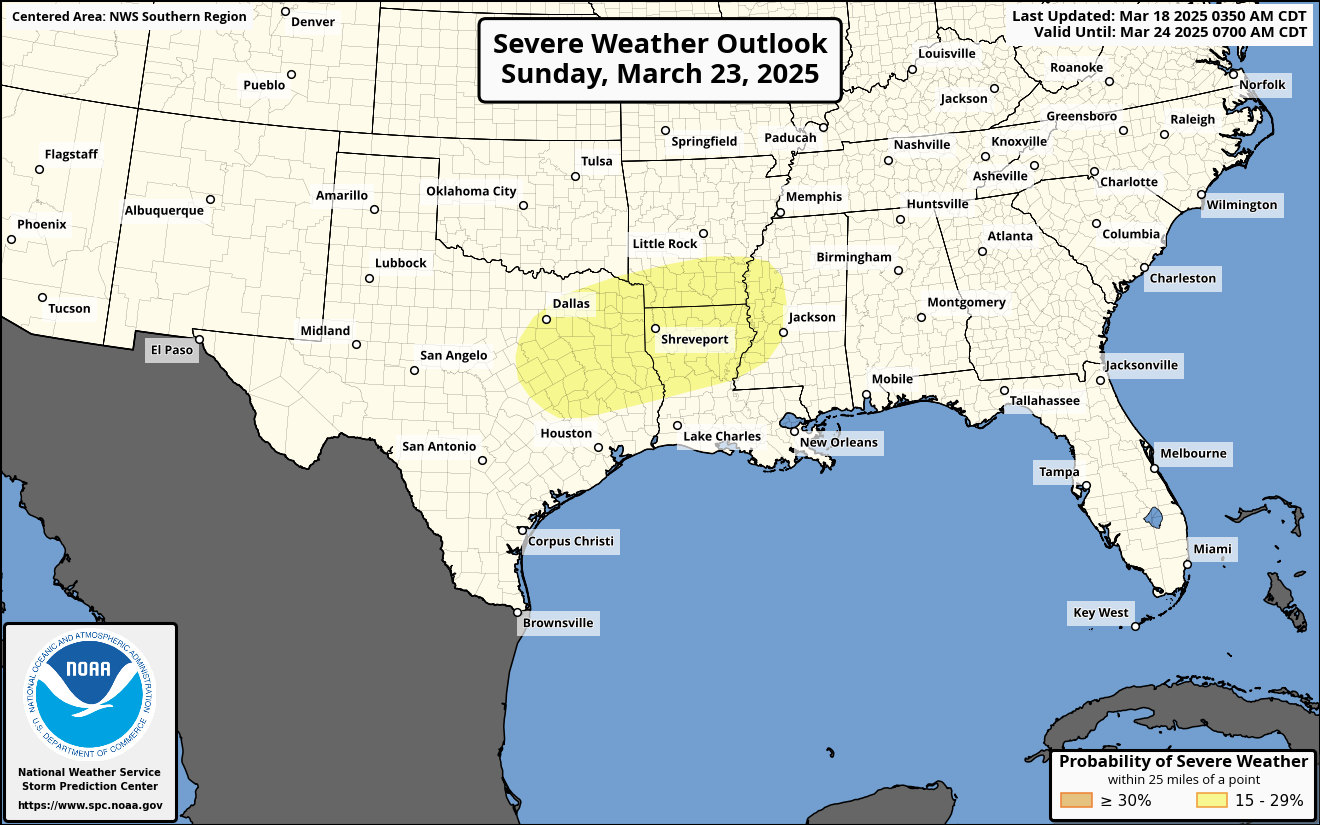
There is a day 6 (March 23rd) 15% risk for severe weather across the ArkLaTex region into Mississippi. The SPC has outlined the primary concerns of isolated severe hail, and severe damaging wind gusts. If you live in the area, please stay alert for updates. #wx #weather #storms #severwx #txwx #arwx #mswx #lawx