#NWS #flood #nwsflashflood #FlashFloodWarning Flash Flood Warning for Bucks, PA; Montgomery, PA; Philadelphia, PA #PAwx https://alerts-v2.weather.gov/search?id=urn:oid:2.49.0.1.840.0.0df95d8707a455d0b538ce7860a3c273d64cfa03.001.1


#NWS #flood #nwsflashflood #FlashFloodWarning Flash Flood Warning for Bucks, PA; Montgomery, PA; Philadelphia, PA #PAwx https://alerts-v2.weather.gov/search?id=urn:oid:2.49.0.1.840.0.0df95d8707a455d0b538ce7860a3c273d64cfa03.001.1
#EAS #WEA for Berks, #PA: National Weather Service: #TORNADO WARNING in this area until 6:45 PM EDT. Take shelter now in a basement or an interior room on the lowest floor of a sturdy building. If you are outdoors, in a mobile home, or in a vehicle, move to the closest substantial shelter and protect yourself from flying debris. Check media. Source: NWS Mount Holly NJ #Berks, #PAwx** DO NOT RELY ON THIS FEED FOR LIFE SAFETY, SEEK OUT OFFICIAL SOURCES ***
THIS WEEK’S WEATHER — #Philadelphia #weather #PAwx
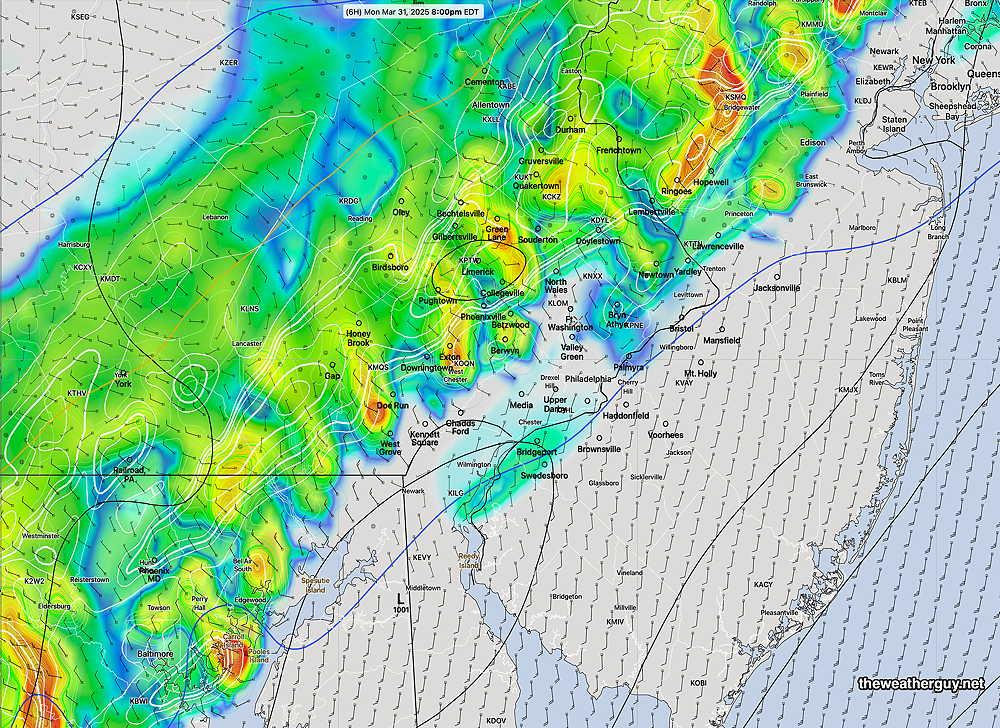
Monday Evening Storm Update
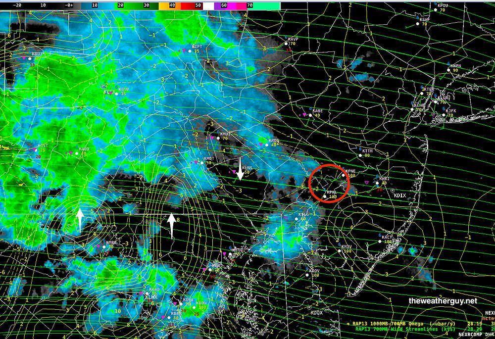
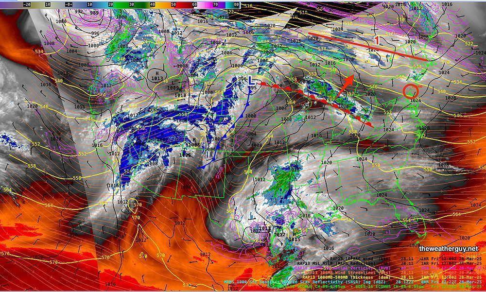
No significant change from previous forecast update. Here's the near-current water vapor/radar— .. https://theweatherguy.net
")
THIS WEEK’S WEATHER — #Philadelphia #weather #PAwx
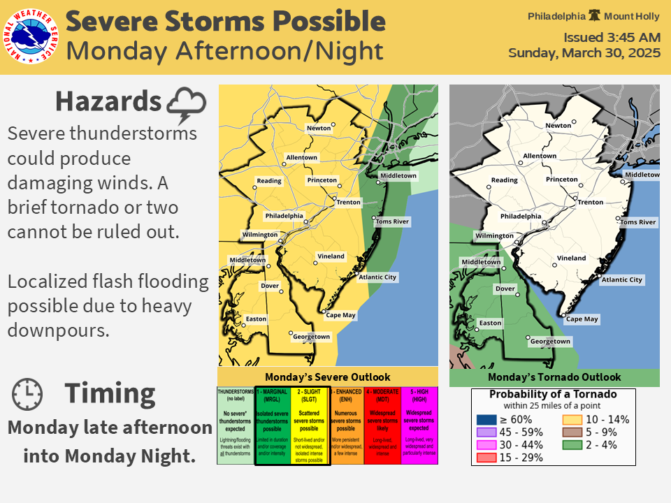
Monday Evening Possible Severe Weather
A strong cold front approaches today and is expected to move through the Philadelphia area about 10 PM. Ahead of the front, unstable conditions will allow for the possibility of severe thunderstorms ahead of the front. The most likely timing is between 6 PM and 9 PM with a peak at 7-8 PM according to the latest HRRR. https://theweatherguy.net

NWS State College PA
519 AM EDT Mon Mar 31 2025
FIRE WEATHER
Cooler & drier conditions are forecast to start April on TUE…Dry air will support relative humidities TUE afteroon falling into the 20s across most of central PA. Gusty NW winds are also possible TUE…the strongest winds will be in the morning. Little to no rain across the central ridge & valley region will leave fuels vulnerable to wildfire spread, while parts of SE PA will hopefully get enough rain to limit concern there...
Area Forecast Discussion
NWS State College PA
519 AM EDT Mon Mar 31 2025
NEAR TERM
…a very warm night for late March, with lows in the mid 50s to low 60s over most of the area…A pre- frontal low level jet & plume of deepest moisture will be over SE PA by late this afternoon with midday breaks in the cloud cover over the E half of the forecast area helping fuel developing convection across primarily SE PA based on the latest CAMs. Storms should become more widespread after 4PM/20Z…
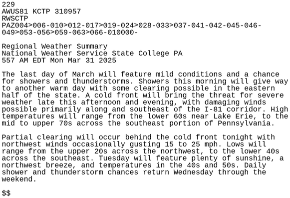
#CTP #PAwx 229
AWUS81 KCTP 310957
RWSCTP
PAZ004>006-010>012-017>019-024>028-033>037-041-042-045-046-
049>053-056>059-063>066-010000-
Regional Weather Summary
National Weather Service State College PA
557 AM EDT Mon Mar 31 2025
The last day of March will feature mild conditions and a chance
for showers and thunderstorms. Showers this morning will give way
to another warm day with some clearing possible in the eastern
half of the state. A cold front will bring the thre https://mesonet.agron.iastate.edu/p.php?pid=202503310957-KCTP-AWUS81-RWSCTP

WEEKEND WEATHER FORECAST — #Philadelphia #weather #PAwx
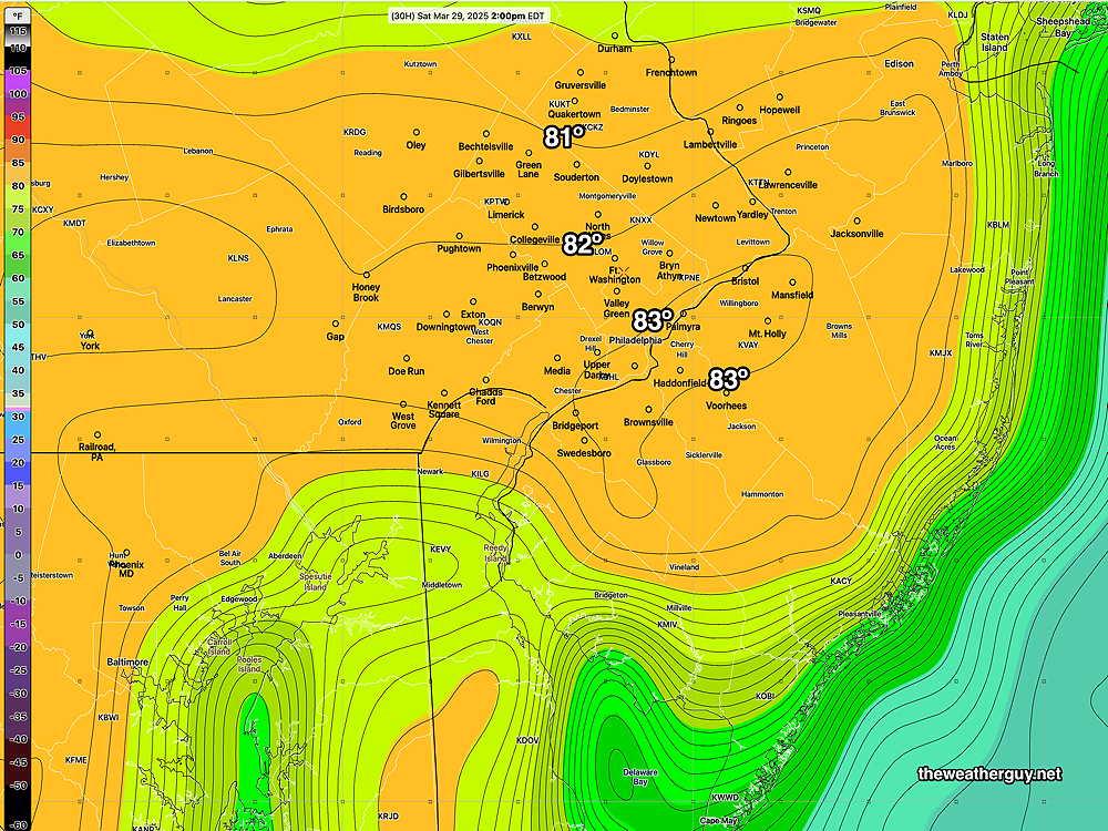
URMA vs RTMA Temperatures
Here's the URMA for 3 PM yesterday, and it shows the ACTUAL recorded [near high] temperatures. Yesterday, there were large differences in the "official temperature" recorded at the airport (KPHL) appearing in the URMA and the provisional temperatures appearing in the RTMA— ... https://theweatherguy.net/blog/?p=23669

Area Forecast Discussion
NWS State College PA
548 AM EDT Sun Mar 30 2025
NEAR TERM
A weak shortwave lifting into the Lower Great Lakes will bring an increased threat of showers today…The highest POPs remain over the NW Mtns, where latest guidance supports near a quarter inch of rain by evening. Any showers that reach the Lower Susquehanna Valley late in the day should be very light…Temps on Sunday will climb +15-20 degrees above the historical average, reaching the 65-75F range…
WEEKEND WEATHER FORECAST — #Philadelphia #weather #PAwx
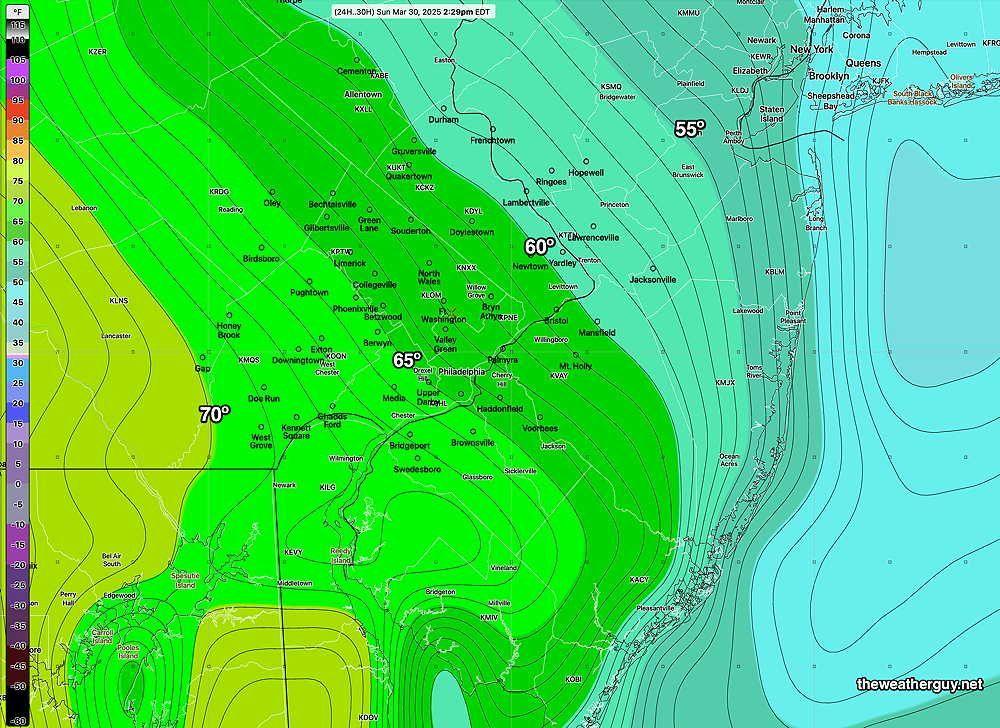
Sunday Forecast Update
The warm front that moved through last night will return as a back door cold front. An easterly wind flow will result in high temperatures almost 20 degrees colder on Sunday compared to Saturday (highs in the low to mid 60s on Sunday). https://theweatherguy.net

NWS State College PA
449 AM EDT Sat Mar 29 2025
FIRE WEATHER
Low humidity (minRH 30-35%) and very breezy conditions (wind gusts 25-35 mph from the southwest) could result in an elevated risk of wildfire spread this afternoon across the south central PA. Recent rainfall only amounted to a few hundredths of an inch for much of the area. With the anticipation of many people heading outside to enjoy the the weather today, please avoid any activities that could create sparks or start a fire!
Area Forecast Discussion
NWS State College PA
449 AM EDT Sat Mar 29 2025
NEAR TERM
…Clear skies & calm winds have allowed temps across much of Central PA to drop into the low to mid 40s early this morning along with some patchy valley fog…high temps in the 70s over most of the forecast area and perhaps the low 80s over the Lower Susq Valley…relative humidity toward 30% in the SE, Lower Ridge & Valley districts for a few hours…will issue a SWS for the elevated risk of wildfire spread…
WEEKEND WEATHER FORECAST — #Philadelphia #weather #PAwx
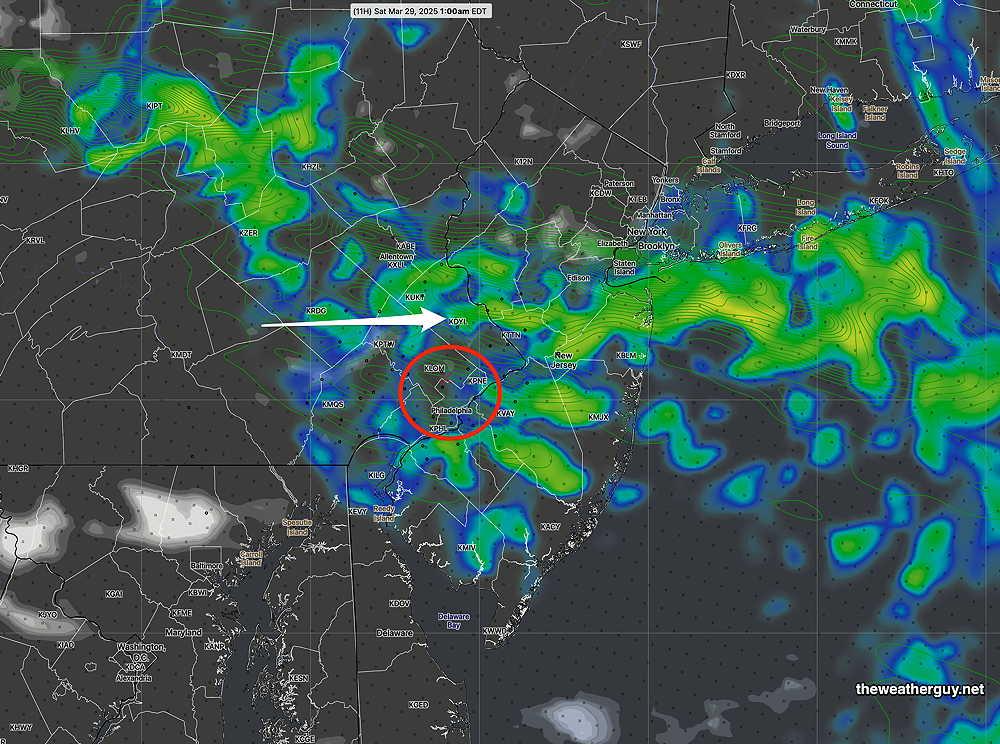
This weekend’s weather will be tricky to forecast accurately. There have already been some surprises in the short term (e.g. a line of showers in Chester County early this afternoon, not forecast by any model.) ... https://theweatherguy.net/blog/?p=23669
THIS WEEK’S WEATHER — #Philadelphia #weather #PAwx
Friday & Weekend Outlook
Over the past several days, there have been significant changes in the model forecasts for this weekend. Here's a brief summary— The warm front will become stationary far north of our area. This area will be the focus of most of the rain for this weekend. ... https://theweatherguy.net/
Area Forecast Discussion
NWS State College PA
502 AM EDT Fri Mar 28 2025
NEAR TERM
…Daybreak readings will range from the low to mid 30s over most of the forecast area…increasing clouds across the region today, with a good chance of showers by afternoon…Rainfall amt will be highest W of I-99, with up to 2/10” possible & generally less than 1/10” E of I-99…expected highs ranging from around 50F over the N Mtns, to around 60F across the Lower Susq Valley…