


#Geospatial analysis of cholera outbreak in Lusaka, Zambia, between 2023 and 2024
https://tropmedhealth.biomedcentral.com/articles/10.1186/s41182-025-00718-4
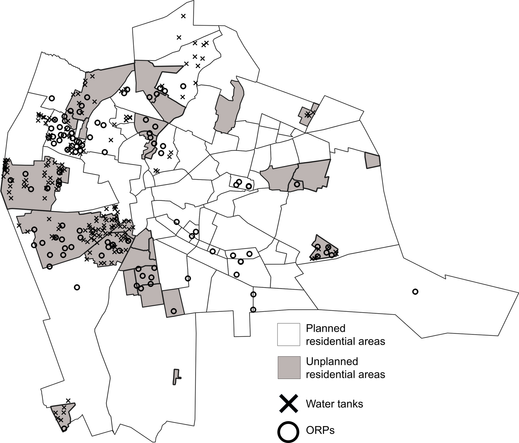
BioMed CentralGeospatial analysis of cholera outbreak in Lusaka, Zambia, between 2023 and 2024 - Tropical Medicine and HealthBackground Cholera outbreaks have plagued Zambia for decades, with Lusaka district, the capital, being particularly vulnerable. Although the lack of sanitary toilet facilities and inadequate drainage systems were shown to be associated with the high cholera incidence in the early 2000s, it is unknown whether these environmental risk factors persisted in the outbreak that occurred in 2023–2024, which turned out to be the largest outbreak in the country’s history. We investigated the geospatial patterns of cholera cases and associated environmental factors during the October 2023 to March 2024 cholera outbreak. Methods We conducted a geospatial analysis of the suspected cholera cases in Lusaka district, comprising seven constituencies and 94 townships. Patient information and geocoordinates were collected from suspected cases using electronic surveillance tools. The space–time scan statistics was performed to detect spatial and temporal clusters of cases. Spearman's rank correlation coefficient, were employed to examine the relationship between cholera incidence and various environmental factors, including access to Water, Sanitation, and Hygiene (WASH) facilities and equipment. Results Over the study period, 4,591 suspected cholera cases with geocoordinate data were identified, with incidence rates varying across the constituencies. Median cholera incidence (IQR) was 0.55 (0.27–1.44) in Lusaka, with higher incidence rates observed in unplanned residential areas. After the first case identification in Kanyama, cases and clusters were observed in different parts of Lusaka. Among 94 townships in Lusaka, cholera-suspected cases were identified in 86 of them. Among environmental factors analyzed for associations with the high cholera incidence, the proportion of individuals without soap and detergent at home (ρ = 0.457, p < 0.001) and those without water for hand washing at home (ρ = 0.421, p < 0.001) were significantly associated with increased cholera incidence. Conclusion The findings underscore the significance of environmental factors in cholera transmission, particularly in unplanned residential areas with inadequate access to WASH facilities which persist in the area. Improving WASH infrastructure and implementing tailored public health strategies, particularly for high-risk areas (e.g., unplanned residential areas), are crucial for mitigating cholera outbreaks in Lusaka District.


 I tried