Recent searches
Search options

Administered by:


#drainage


 Greg Cocks
 Grfin Tools—User Guide And Methods For Modeling Landslide Runout And Debris-Flow Growth And Inundation
--
https://pubs.usgs.gov/publication/tm14A3 <-- shared USGS publication
--
https://code.usgs.gov/grfintools/grfintools <-- shared USGS software release
--
H/T Jonathan Perkins USGS
[ another open source resource for everyone from the USGS ~smile~ ]
#GIS #spatial #mapping #opensource #openlibrary #Grfin #software #package #regional #debrisflow #engineeringgeology #geology #inundation #spatialanalysis #spatiotemporal #geophysics #geophysical #massmovement #landslide #lahar #volcano #rock #avalanche #model #modeling #statistical #geostatistics #water #hydrology #downstream #elevation #remotesensing #DEM #flow #runout #risk #hazard #tools #slope #erosion #drainage #network #channel #channelisation #userguide
@USGS

https://www.europesays.com/1837289/ White House mayor halts construction as flooding concerns rise #construction #Development #drainage #flooding #infrastructure #MayorCorbitt #stormwater #TheWhiteHouse #TrumpAdministration #WhiteHouse
Evidenced Paleodrainages In Desert Regions Of Saudi Arabia - Satellite Images With Field-Based Study
--
https://doi.org/10.21203/rs.3.rs-4959129/v1 <-- shared paper
--
#GIS #spatial #mapping #water #hydrology #streams #poroussediments #pebbles #RadarImages #SaudiArabia #MiddleEast #remotesensing #drainage #paleodrainage #desert #evidence #satellite #imagery #fieldwork #fieldchecked #Quaternary #Pleistocene #climatechange #geology #landform #geomorphology #arid #streamnetwork #PALSAR #ASTER #thermaldifferentiation #spatialanalysis #multispectral #sediment #lithology #hydromorphic #geomorphmetry #waterresources #usecase
USDA 2024 Aerial Imagery Now Available For Download In Texas!

--
https://datagateway.nrcs.usda.gov/ <-- shared USDA Geospatial Data Gateway (i.e., download the raster aerials here)
--
“The USDA has released its 2024 National Agriculture Imagery Program (NAIP) aerial imagery, providing high-resolution, 1-meter data for all 254 Texas counties… Newly built bridge and highway infrastructure Stormwater & drainage evaluations (newly built drainage infrastructure) Right-of-way assessment (environmental analysis)…”
#GIS #spatial #mapping #RemoteSensing #NAIP #USDA #SpatialAnalysis #GISCommunity #AEC #AerialImagery #GISchat #InfrastructurePlanning #CivilEngineering #TransportationPlanning #LandSurveying #EnvironmentalAnalysis #EngineeringInnovation #opendata #Texas #USA #imagery #infrastructure #stormwater #drainage #rightofway #environmental #bridge #highway #planning #management #resource #reference
@USDA @NRCS

 now
now
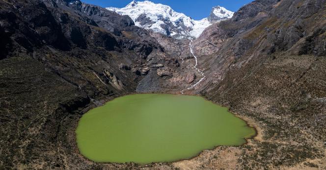
As the glaciers of South America retreat,
the supply of freshwater is dwindling
and its quality is getting worse.
The Cordillera Blanca mountain range harbors the world’s largest concentration of tropical glaciers,
which are particularly sensitive to rising temperatures and are a major source of freshwater in Peru.
For thousands of years, the glaciers were replenished with ice in the winter.
But they have shrunk by more than 40 percent since 1968,
uncovering rocks that, when exposed to the elements, can trigger chemical reactions that leach toxic metals into the water and turn it acidic.
The process, known as #acid #rock #drainage,
“creates a cascade reaction that pollutes water sources,”
said Raúl Loayza, a biologist at Peru’s Cayetano Heredia University who researches water quality in the Andes.
“It’s a big problem and is getting worse and worse.”