R package StratPal update
Full integration with the FossilSim package to study effects of #taphonomy and #ecology on #phylogenetic trees with sampled ancestors, and simplified handling of categorical niche models
#stratigraphy
https://mindthegap-erc.github.io/StratPal/index.html
Recent searches
Search options
#Stratigraphy
Join us in #Utrecht for a meeting on #reproducibility in #stratigraphy, #Earth
and #climate history and #astrochronology. We offer workshops on #StratigraphicModelling, #Age-DepthModels and #CodeReproducibility for #earthscience professionals and students. If you want to join a field trip to the #Devonian and #Carboniferous of #Belgium
, make sure to register quickly!

Interested in #reproducibility, #methodology and #uncertainty reporting in #stratigraphy?
Excited to announce the CycloNet meeting 2025 in Utrecht , bringing together cyclostratigraphers and researchers from adjacent fields to discuss methodology, uncertainty, and reproducibility
Registration: forms.office.com/e/UrVjH0iH3s
Conference info: https://www.uu.nl/en/research/department-of-earth-sciences/cyclonet-meeting-utrecht
Student and hybrid participation is free!
Seismometers Reveal Earth's Longest-Runout Undersea Sediment Flows In Unprecedented Detail
--
https://phys.org/news/2025-02-seismometers-reveal-earth-longest-runout.html <-- shared technical article
--
https://doi.org/10.1038/s43247-025-02137-z <-- shared paper
--
https://doi.org/10.1016/j.geomorph.2024.109350 <-- shared paper
--
https://doi.org/10.1038/s41561-022-01017-x <-- shared paper
--
#GIS #spatial #mapping #remotesensing #Congo #CongoChannel #bathymetry #seismometers #monitoring #sediment #flow #submarine #massmovement #canyon #infrastructure #pipes #cables #engineeringgeology #geology #model #current #debrisflow #bathymetric #Africa #offshore #coast #coastal #river #WestAfrica #instrumentation #acoustic #doppler #moorings #turbidity #thalweg #morphology #landslides #stratigraphy #seismic #turbiditycurrent #flow #gradient #slope #erosion #risk #hazard #spatialanalysis #spatiotemporal #seabed
New Publication
Seamlessly integrate #stratigraphy, #taphonomy, #ecology and evolutionary biology to build your modeling pipelines for stratigraphic #paleobiology
Published in Methods in Ecology and Evolution , R package available on CRAN
@Emiliagnathus
https://besjournals.onlinelibrary.wiley.com/doi/10.1111/2041-210X.14507
This commemorative publication is dedicated to Dr. S. Omura who initiated the founding of the Japanese Institute of Anatolian Archaeology in Turkey in 1998. The articles present among other things recent research and analyses on Anatolian #stratigraphy.
Edge Of Mars’ Great Dichotomy Eroded Back By Hundreds Of Kilometres
--
https://arstechnica.com/science/2025/01/field-of-mounds-on-mars-may-be-sign-of-erosion-at-the-edge-of-an-ocean/ <-- shared technical article
--
http://dx.doi.org/10.1038/s41561-024-01634-8 <-- shared paper
--
#GIS #spatial #mapping #planet #Mars #remotesensing #imagery #landsurface #geology #topography #astrogeology #elevation #morphology #martian #geography #marsdichotomy #plateau #lowlands #model #3dmodel #basin #highlands #shoreline #ocean #crust #structuralgeology #chemostratigraphy #morphostratigraphy #geomorphometry #geomorphology #water #hydrology #CaSSIS #HiRISE #stratigraphy #strata #MOLA #laser #LiDAR #MawrthVallis #crater #mound #profile #crosssection #geochemistry #mineralogy #CRISM #CTX #HRSC #DTM #erosion #weathering #spatialanalysis #spatiotemporal
‘Mystery Volcano’ That Erupted And Cooled Earth In 1831 Has Finally Been Identified
--
https://www.accuweather.com/en/weather-news/mystery-volcano-that-erupted-and-cooled-earth-in-1831-has-finally-been-identified/1729581 <--shared technical article
--
https://doi.org/10.1073/pnas.2416699122 <--shared paper
--
#GIS #spatial #mapping #glaciochemical #geochemistry #climate #climatechange #sulfurdioxide #neversummer #temperature #weather #icecore #LittleIceAge #dating #model #modeling #spatialanalysis #historic #volcanic #eruption #stratigraphy #Zavaritskii #caldera #ash #KurilIslands #Japan #Kamchatka #Russia #volcano #stratospheric #cryptotephra #tephra #andesite #dacite #Simushir #SimushirIsland
“To cross the southern coast of England, west to east, is thus to travel forwards - and at breathtaking chronological speed - in a self-propelled time-machine. With every few hundred yards of eastward progress one passes through hundreds of thousands of years of geological time: a million years of history goes by with every couple of miles march.”
― Simon Winchester, The Map That Changed the World: William Smith and the Birth of Modern Geology
In 1793, William Smith, was a surveyor by trade and trained in mapping and geometry. He apprenticed under England’s master surveyor, and traveled all over England surveying for canals. Smith became an expert in England’s rocks noting that they, and the fossils they contained, occurred in vertical layering representing successively older rocks the deeper he dug, and that the fossils within changed the deeper he went. Smith realized that the same sequences of rock could be correlated over vast horizontal distances, indeed over the entirety of England, and could be used to trace the underpinning rock to facilitate mapping. His epiphany became the Principle of Faunal Succession and became the key to unlocking Deep Time.
https://www.earthobservatory.nasa.gov/features/WilliamSmith/page3.php
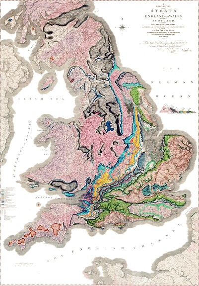
Smith began traveling all across England while surveying for minerals, noting the rocks and fossils and began recording and mapping the rocks, choosing a different color for each rock type and estimating the extent and boundaries it covered. In 1815 he published his geological map which covered England, Wales, and part of Scotland and contained a stratigraphical analysis with the fossil index of each layer. It was the largest geological map of its time and contained a geological cross-section that revealed the 3D geometry of the rock beds.
Sadly, William Smith fell upon rough times, and it wasn’t until 1831 that he became widely recognized as the Father of English Geology and Stratigraphy, and he was bestowed with honorary degrees, titles, and a pension for the rest of his life. His beautiful map remains today as one of the greatest breakthroughs in Geology.


